Just a quick heads up – some of the links I share on this site are affiliate links. That means if you click on one and make a purchase, I may earn a small commission at no extra cost to you. Your support through these links helps me create valuable content.
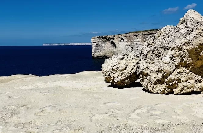
I’ll be honest upfront: if you want the best hiking Malta has to offer, start with the coastal walks. The cliff paths along the west coast, the Dingli Cliffs, Għajn Tuffieħa to Għnejna – those are the ones that stay with you. The Victoria Lines are a different kind of hike. This is the one for people who are already curious about history, who have done the coastal routes, and who want to understand the island from a different angle.
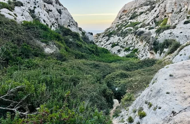
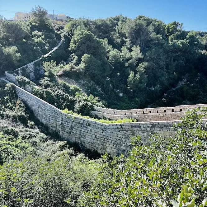
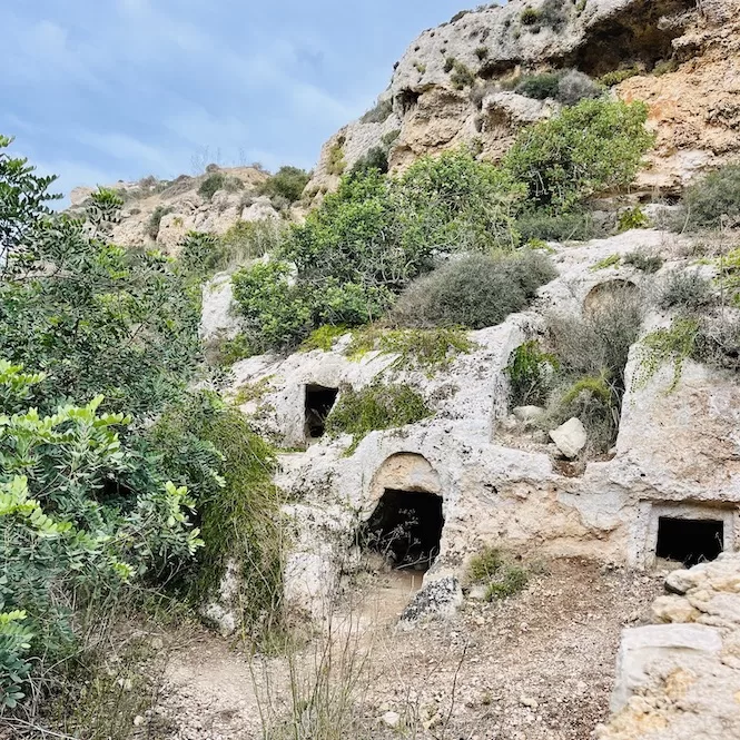
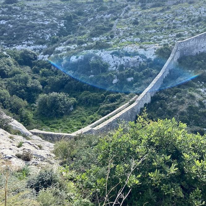
That said, the Bingemma Gap section, where the wall bridges a deep green valley with caves carved into the rock face and the sea visible on both sides, is unlike anything else I have walked in Malta. When I first got there it felt different from every other hike on the island. Some people compare it to the Great Wall of China. I can see why.
One warning before you go: finding the trail is the hardest part of the whole experience. I got lost on my first attempt. I will tell you exactly where it happens so you don’t waste the time I did.

Written by Laura Jasenaite, Malta travel expert with 15+ years living on the islands.
What are the Victoria Lines?
The Victoria Lines are a 12 km defensive fortification built by the British military in 1897, named in honour of Queen Victoria’s Diamond Jubilee. The purpose was to protect the Grand Harbour from any invasion coming from the north of the island.
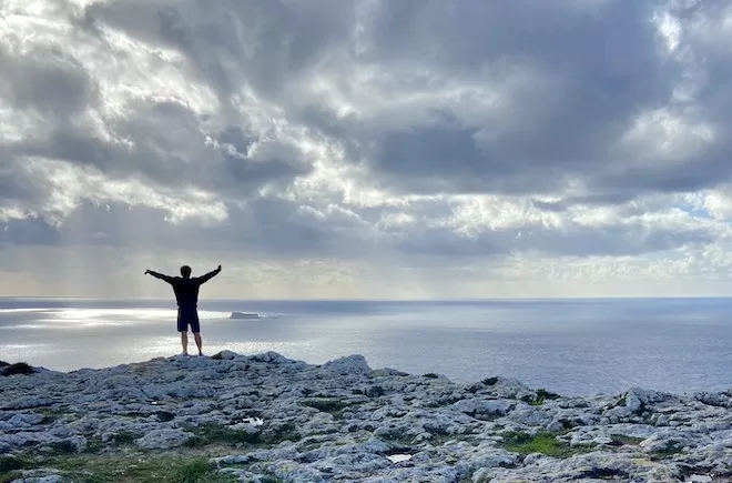
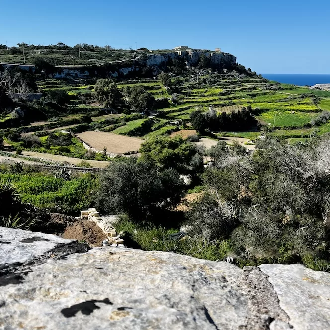
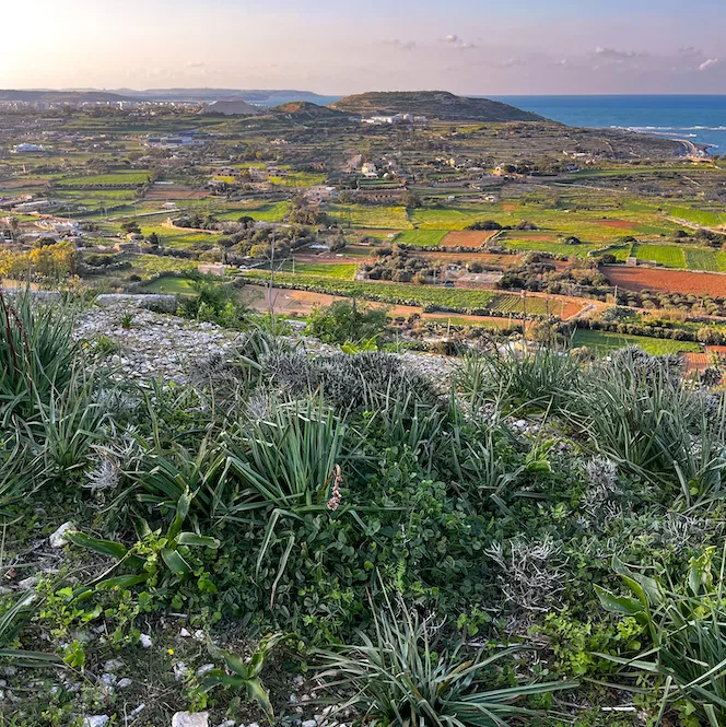
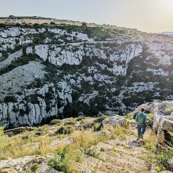
They run along a natural geological fault line that divides Malta into higher and lower ground. You cannot really see this fault when you drive around Malta, but on the trail it becomes obvious: you are walking along what feels like a giant step, with the lower northern half of the island spread out below you and Gozo on the horizon.
Military exercises in May 1900 revealed the Lines were not particularly effective as a defence. The British abandoned them in the early 20th century. What remains is a mixture of surviving wall, forts, gun emplacements, trenches, and gaps where the wall has been quarried away entirely.
Should you do this hike?
If you enjoy hiking and want the best of Malta’s landscape, there are more dramatic walks elsewhere on the island. The coastal routes offer scenery that the Victoria Lines cannot match.
The Victoria Lines are worth doing if you are interested in military history, want to see the island from the ridge rather than the coast, or have already done the main coastal hikes and want something different.
The Bingemma Gap section in particular is genuinely worth the effort. A wall bridging a deep green valley, caves in the rock below, sea views in both directions on a clear day: in winter and spring when everything is green, it is a surprisingly beautiful place.
The eastern section from Fort Madliena to Naxxar is short and easy and good for a half-day. The western section from Kuncizzjoni to Mosta is longer, more varied, and has the better scenery.
Western section: Kuncizzjoni to Mosta
TRAIL INFO:
- Distance: 9.18 km
- Duration: 2 hours 30 minutes walking / allow 3.5 hours with stops
- Difficulty: Intermediate — mostly flat ridge, one descent, some rough terrain
- Elevation: +70 m uphill / -200 m downhill
- Highest point: 230 m
- Trail type: Point-to-point
- Start: Kuncizzjoni, near the church (see location here)
- End: Mosta Bride Garden (see location here)
- Best season: October to May
- Avoid: Midday in summer — minimal shade on the ridge
- What to bring: 1.5 litres water per person (no facilities on route), sturdy walking shoes, sun protection, food for lunch
- Getting there: Bolt or taxi (approx €15-20 from central Malta) recommended. Bus 109 from Siggiewi via Rabat to Wied Gerzuma stop, every 2 hours. On-street parking available near the church.
Eastern section: Fort Madliena to Naxxar
TRAIL INFO:
- Distance: 2.80 km
- Duration: 50 minutes walking / allow 1.5 hours with stops
- Difficulty: Easy
- Elevation: +50 m uphill / -70 m downhill
- Highest point: 140 m
- Trail type: Point-to-point
- Start: Fort Madliena (see location here)
- End: Triq John Adye, Naxxar (see location here)
- Best season: October to May
- Avoid: Midday in summer
- What to bring: Water, sun protection, comfortable walking shoes
- Getting there: Bus to Dis stop (5-min walk to fort, every 20 mins).
- Car park at Fort Madliena and limited parking at San Giovanni Battery.
The single most important thing to know: navigation
Signposting has been improving since 2025 but remains inconsistent in places. Getting lost is genuinely easy, particularly for first-time walkers.
The two places where it consistently goes wrong are at the start and in the middle.
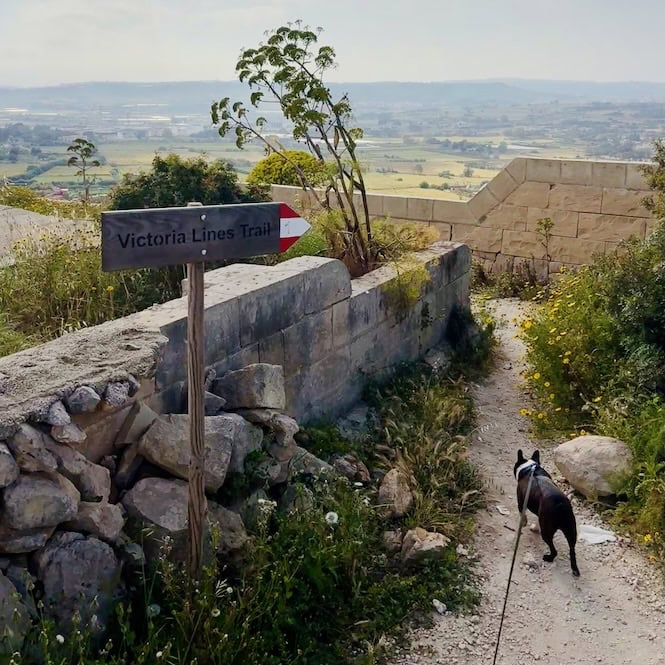
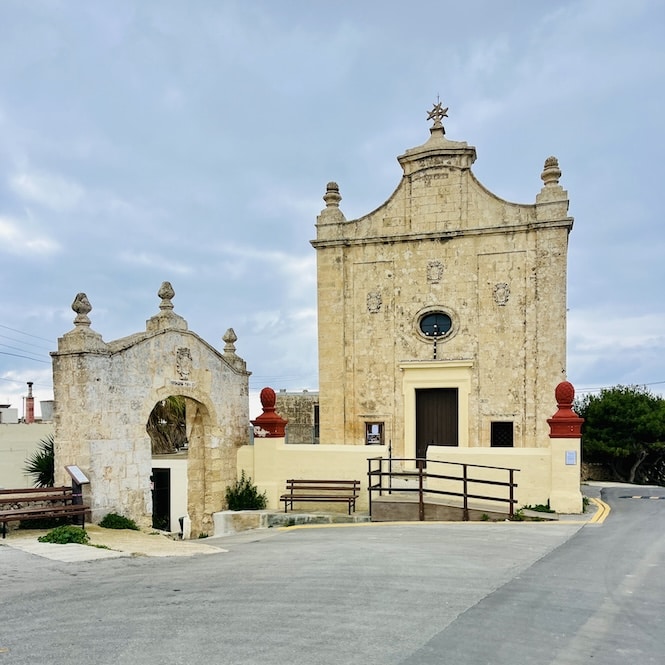
At Kuncizzjoni in the west: This is the most confusing section on the whole trail. The wall actually begins further west of the church, but that initial stretch is hard to find. Start from the church instead: turn your back to the church door and follow the dead-end road in front of you. The wall appears on your left at the end of it. Do not try to navigate from memory. Download the Komoot app and load the Victoria Lines trail map before you set off.
Between Naxxar and Mosta: The wall has been largely destroyed through this middle section, partly from quarrying. You will lose the trail on both sides. Do not try to walk this stretch: it is a busy dusty road with no views and no wall. Take bus 103 from the Birguma stop to MCAST Mosta, or use a Bolt.
There are also stretches blocked by private property signs. Some are legitimate; others have been put up informally by hunters or farmers. Use the Komoot map to navigate around them.
Western section: Kuncizzjoni to Mosta
Kuncizzjoni to Fort Bingemma (30 minutes)
Start from the church at Kuncizzjoni and follow the dead-end road behind it. The wall appears on your left. From here the views open up immediately: on a clear day you can see Għajn Tuffieħa, Golden Bay, and the white cliffs of Gozo across the water.
After about ten minutes following the wall, a path leads down into a field with a private sign. Do not follow it. Keep right and find the way up the hill. The wall disappears shortly after and you follow a quiet village road for around 20 minutes to Fort Bingemma. Not the most exciting stretch, but the countryside views are decent and it is very quiet.
Fort Bingemma
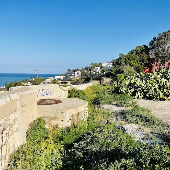
Fort Bingemma was built between 1875 and 1878, initially armed with guns to defend northern Malta. Now it is neglected but structurally intact.
Worth knowing: the fort was illegally occupied by a Maltese family from 1981 onwards, long after their lease expired in 2009. The Buttigieg family farmed the site for decades before the government finally reclaimed it in August 2025. It is now managed by Xjenza Malta.
Get a FREE Attractions Map
Planning a trip to Malta, Gozo, or Comino? Get this free interactive map filled with insider tips, Google Maps links, and more.
Fort Bingemma to Bingemma Gap (the section worth coming for)
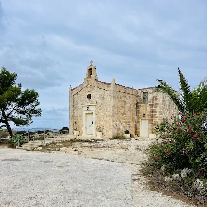
From the fort, descend slightly and follow the wall. On your left a deep green valley opens up with pine trees. In the distance, the small white chapel of Our Lady of Hodegetria Chapel appears. It is slightly off route but the surroundings are peaceful and there are caves in the valley below, accessible by walking down on the right side of the chapel.
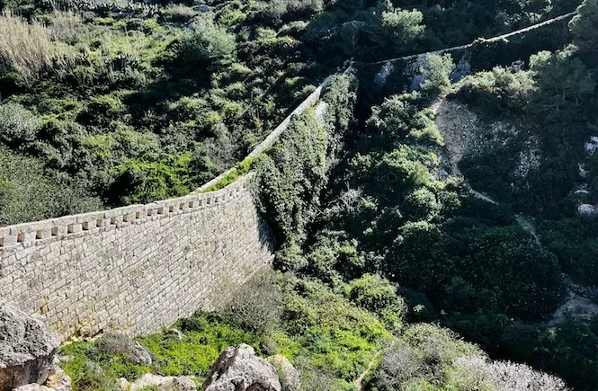
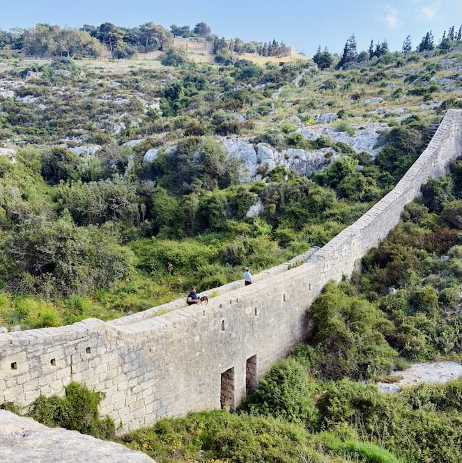
The path then reaches the most photographed section of the whole trail: the defensive wall bridging Bingemma Gap. A valley stretches below you, very green in winter and spring. The sea is visible in both directions on a clear day. The caves in the rock face are accessible from the valley floor. Locals call this the Great Wall of Malta. It is the right place to stop for lunch.
Dog owners: the trail is generally dog-friendly but keep them on a lead. There is a farm near the Dwejra Lines section where dogs sometimes run out.
Want to plan your whole Malta trip without the stress?
My 7-Day Malta Itinerary handles the routes, timings, and where to start, so you can just be there. Less planning. More Malta.
Dwejra Lines
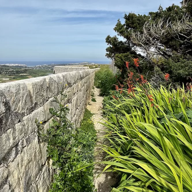
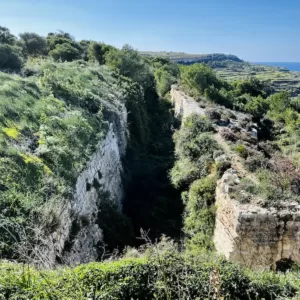
After the gap, walk uphill to a path lined with pine trees with a village road on your right. Stay on the path. From the Dwejra Lines you can see both the east and west coasts of Malta at the same time, which is something you rarely get on a small island. The route follows a trench with gun emplacements still visible along the way.
Sundays and public holidays this section attracts local families for picnics. Expect some company.
Dwejra Lines to Mosta (40 minutes downhill)
Follow the path through Falka Gap and Targa Gap down to Mosta. As you descend, cars and urban noise grow louder. The stretch passes quarry areas that are quiet at weekends but dusty. Take care crossing the road between Mosta and Mġarr. The walk ends at Mosta Bride Garden, where the wall has been partially restored and there are benches to sit on.
Fort Mosta is nearby but is an active ammunition depot for the Armed Forces of Malta. It is not open to the public.
Eastern section: Fort Madliena to Naxxar
Fort Madliena is near Gharghur in the east of Malta. The nearest bus stop is Dis, about five minutes from the fort, with buses every 20 minutes. There is a car park at the fort and on-street parking nearby.
Fort Madliena to San Giovanni Battery (15 minutes)
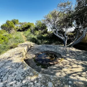
The walk from the fort to San Giovanni Battery follows a quiet road past villas and trees. Fort Madliena itself is 132 metres above sea level and was used by the British to house large guns. Today St John Rescue Corps Malta uses it for training. San Giovanni Battery has two concrete gun emplacements and is actually the better starting point if you want to skip the road section. There is a small car park nearby.
San Giovanni Battery to the Top of the World in Għargħur
From the battery, follow the wall along a narrow path that is occasionally overgrown enough to feel like you are pushing through vegetation. Then the path opens onto a stone bridge over the Wied il-Faħam Valley, similar to Bingemma Gap but quieter and less visited.
After the bridge, a steep path climbs to the viewpoint locals call the Top Of The World in Għargħur. It is a simple spot: a high point on the ridge with unobstructed views across a large part of Malta. Locals come here for sunsets.
Top of the World to Naxxar (10 minutes)
Follow the paved path to Wied Anglu, a picturesque valley on your right. Continue along the wall for five to ten minutes until you reach Triq John Adye road. The wall ends here – it has been destroyed beyond this point. This is where the eastern section finishes.
To continue to the western section, take bus 103 from Birguma stop to MCAST Mosta, or use a Bolt. Do not walk the road.
What to bring
There are no facilities of any kind along either section of the trail. No cafes, no taps, no shops. Bring everything before you start.
Water is the most important thing. At least 1.5 litres per person for the western section, more in warm weather. The eastern section is short enough that 0.75 litres is usually fine.
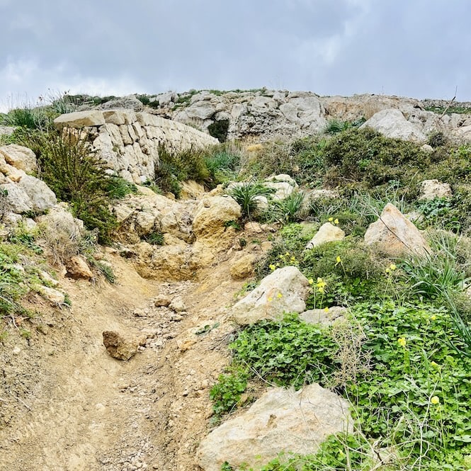
Wear proper walking shoes. The western section has rocky and uneven ground in places and can be slippery after rain. Trainers are adequate for the eastern section but sturdy footwear is worth having for the full western route.
Sun protection from April onwards: hat, sunscreen, and a long-sleeved layer for the exposed ridge. The Dwejra Lines section in particular has almost no shade.
Bring food for the western section. Bingemma Gap is the natural lunch stop and nothing is available to buy nearby.
When to go
October to May is the best window. The trail is green, temperatures are comfortable for walking, and the views to Gozo are clearest in winter and early spring.
Avoid July and August if you can. The exposed ridge is genuinely punishing at midday in summer and the vegetation dries out completely, which changes the character of the walk.
If you go in summer, start no later than 7am. By 10am on the western section it is too hot to be enjoyable.
My honest take
The Victoria Lines are worth doing once if you are curious about Malta’s layers of history or want a view of the island that most visitors never find. The Bingemma Gap section is genuinely unlike anything else in Malta.
But I would not put this at the top of the list for first-time visitors. Do the coastal walks first. Come back to this one when you want to go deeper.
If you want your whole Malta trip planned with the same logic — the right walks in the right order, with the time and logistics worked out, that is what my 7-Day Malta Itinerary is for.
Frequently Asked Questions
How long is the Victoria Lines hike in Malta?
The full trail is around 12 km but is walked in two separate sections with a destroyed middle stretch that you need to travel by bus or taxi. The western section (Kuncizzjoni to Mosta) is 9.18 km and takes around 2 hours 30 minutes. The eastern section (Fort Madliena to Naxxar) is 2.80 km and takes around 50 minutes.
What is the best section of the Victoria Lines to walk?
The Fort Bingemma to Bingemma Gap section in the west is the highlight. A wall bridges a deep green valley with caves below and sea views in both directions. If you only have time for one section, do this one. The Dwejra Lines section immediately after it is also excellent for views of both coasts.
How difficult is the Victoria Lines hike?
The western section is intermediate: mostly flat ridge walking with one longer descent, some rough rocky terrain underfoot, and minimal shade. The eastern section is easy. Neither is technically challenging but the western section requires careful navigation in places where the trail becomes unclear.
Is the Victoria Lines well signposted?
Improving since 2025 but still inconsistent. The start at Kuncizzjoni is the most confusing section. Download the Komoot app and load the Victoria Lines trail map before you go. Do not rely on online descriptions alone.
When is the best time to walk the Victoria Lines in Malta?
October to May. The trail is exposed with very little shade. Avoid July and August if possible. If you go in summer, start before 7am.
Can you walk the Victoria Lines in one day?
Yes, but you will need to travel between the two sections. The middle stretch between Naxxar and Mosta has been destroyed and you need to take bus 103 or a Bolt to bridge the gap.
Why were the Victoria Lines built?
The British military built them in 1897 to defend the Grand Harbour from any invasion coming from the north of the island. They were named in honour of Queen Victoria’s Diamond Jubilee. Military exercises in 1900 showed they were not effective and they were abandoned shortly after.
Is there parking at the Victoria Lines?
t the western start (Kuncizzjoni), on-street parking is available along the road near the church. At the eastern start (Fort Madliena), there is a small car park and some on-street parking.
Looking for more hikes in Malta? Here are my other trail guides: