Just a quick heads up – some of the links I share on this site are affiliate links. That means if you click on one and make a purchase, I may earn a small commission at no extra cost to you. Your support through these links helps me create valuable content.
Embarking on the St. Thomas Bay Hike in Malta’s south is an amazing adventure. If you’re looking for a unique hiking experience, this is it. The St. Thomas Bay to St. Peter’s Pool journey shines. White cliffs, a limestone arch, and lush greenery await.
You must be wondering what makes this hike in Malta’s south unique. You will pass through a stunning limestone arch. Then, you will see steep white cliffs. You will be surrounded by gorgeous sea views, lush greenery, and blooming flowers. The walk ends at St. Peter’s Pool, a natural, rocky beach with amazing rock formations.
Living in Malta since 2011, I’ve explored all of Malta’s coastline and its beautiful hikes. I enjoy sharing my knowledge and showing off Malta’s beauty.
In this post, I have included route info for the St. Thomas to St. Peter’s Pool walk. I’ve added a detailed map to guide you and practical advice to prepare you for the hike.
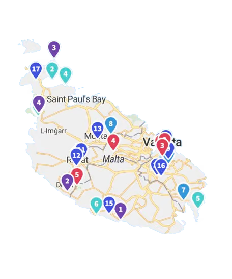
St. Thomas Bay Trail Map leading to St. Peter’s Pool
Things to Know before you Hike in Malta’s South
In some places, the path goes along the cliff edge. So, be cautious as you navigate it. This hike may not be for you if you’re scared of heights.
It’s also wise to come prepared. Wear sturdy shoes since some parts of the path have loose stones.
The trail can be challenging to see at some points, so follow the map. Don’t worry; you won’t get lost. But you might miss the path along the water edge with pretty views.
I also recommend bringing plenty of water since no shops are nearby. Bring food if you want to have a picnic with a view. After the hike, you can enjoy lunch at one of the St. Thomas Bay restaurants.
- Distance: 8,87 km
- Walking Time: 2 h 15 mins
- Level: Intermediate
- Uphill: 130 m
- Downhill: 130 m
- Highest Point: 60 m
During June and September, avoid the midday heat.
St. Thomas Bay: the Starting Point of the Hike
St. Thomas Bay is the starting point for the hike through Malta’s South. It’s easy to get there by bus.
Getting There:
- Location: link to Google Maps
- Nearest bus stop: Bajja
- Walking distance from the bus stop: 500 meters
- Frequency of the buses: every 30 minutes
- Parking available: Along the road, there is plenty of parking
Get a FREE Attractions Map
Planning a trip to Malta, Gozo, or Comino? Get this free interactive map filled with insider tips, Google Maps links, and more.
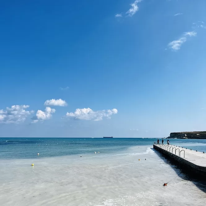
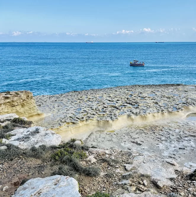
St. Thomas Bay is a lovely tranquil bay with shallow clear waters. There are plenty of amenities around. There are a few restaurants, kiosks, an ice cream van, a shower and public toilets.
The beach itself is tiny and frequented by locals. In the summer, it can get busy with locals who come to launch their boats into the water from the bay. While the beach may not be special, this area is a great starting point for hiking and exploring the south coast and all its hidden gems.
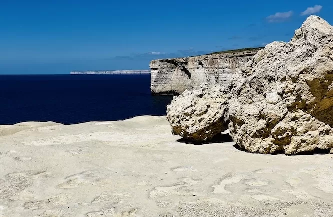
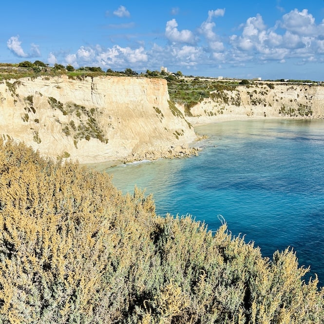
Munxar Point: Stunning Limestone Arch and White Cliffs
Once you’ve crossed St. Thomas Bay, walk along the water on the Munxar Path. On your left, you’ll see a rocky plate. Take some nice pictures down there.
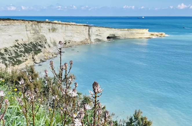
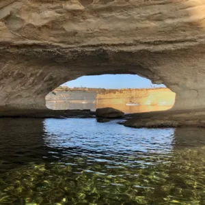
Soon you will reach Munxar Point. You’ll find the Munxar Arch there. It is a striking limestone formation that stands out against the blue sea. A shallow bay in front of the arch is perfect for swimming and snorkelling. You can even swim through the arch when the waters are calm.
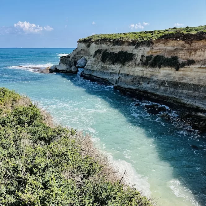
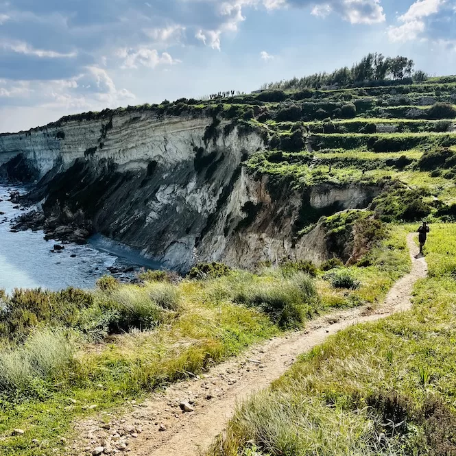
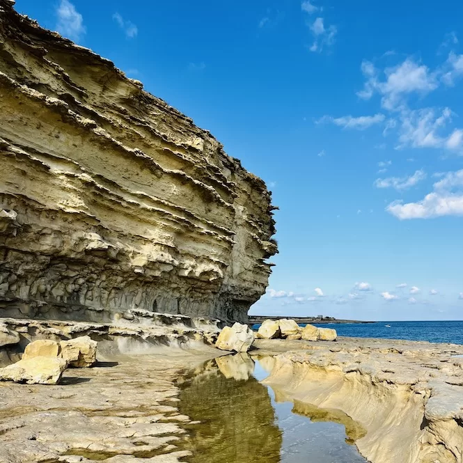
After, take a short 200-meter hike up. Finally, you will get to the viewpoint of the white limestone cliffs surrounding the area.
These cliffs are lighter in colour than others you’ll find in Malta. They create a striking contrast against the beautiful blue waters below. The sea may appear turquoise or green depending on the time of year and the weather.
You can’t walk down the cliffs, but you can enjoy the view from the top or get closer by paddle boarding or kayaking.
Kayaking or paddle boarding are awesome ways to explore this place. Book a kayak or paddle boarding adventure if you’re interested. Be sure to bring your camera to capture the stunning scenery.
Xrobb L-Ghagin Area
Follow the path uphill. It’ll get farther away from the water. Don’t miss big agave plants that line the route.
Soon you’ll come across a small village chapel. Take a moment to enjoy the chapel’s beauty before turning left towards Xrobb l-Għaġin.
Xrobb l-Għaġin is the only nature park in the south of Malta. There is a small educational centre that offers visitors some insights into Malta’s natural flora and fauna. This area is also a popular spot for picnics. Xrobb l-Għaġin isn’t part of this hike, but you can explore it and use the map to get back to the route.
So, after passing the charming village chapel, keep walking downhill for a little while. You will soon reach a point where you have to turn right. There’s a small path that leads down towards the coast. However, it may be tricky to find it as the entrance isn’t obvious.
For the longest time, I had no idea that walking along the water’s edge was possible. I always used to stick to the road, but I was missing out on so much. Walking along the coast is so much more picturesque. Don’t make the same mistake I did; make sure to look out for the path!
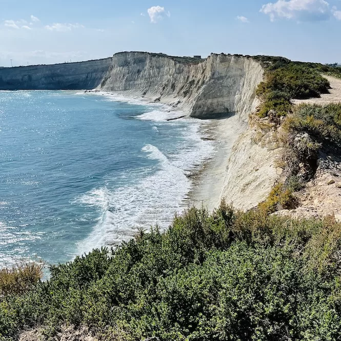
Hofriet Window and Ras il-Fenek Peninsula
Take a walk along the narrow path on the cliff’s edge and take in the view. It’s so pretty in spring, with greenery and wildflowers that contrast beautifully against the blue water.
As you continue walking, you notice a sea window connecting two bays. It’s called the Hofriet Window. It is an incredible sight. It’s hard to resist getting closer. Unfortunately, there is a very steep path to get there. A safer option is to get there by boat or kayak.
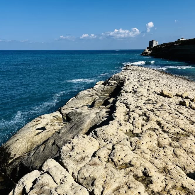
Walk along the coastline till you reach a beautiful spot called Ras il-Fenek. This area is a peninsula that sits on top of the sea window. It offers breathtaking views of the surrounding turquoise waters and white cliffs.
If you’re up for a swim, Ras il-Fenek is a perfect spot. But be prepared for a rocky entry to the sea, so water shoes are a good option.
The area is tranquil, and you’ll likely have a place for yourself with only a few boats passing by. So take some time to relax and enjoy the beautiful scenery before you continue your journey.
As you continue your trek along the water, after about 10 minutes, you will come across a small road. Be careful, as there may be cars passing by.
From this road, you can see the Hofriet Window from a different angle. The view is just as stunning.
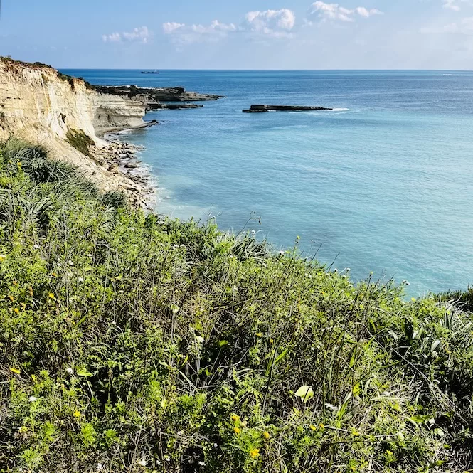
Follow the road down the coast, and soon you’ll be around the corner from St. Peter’s Pool. As you make your way, take notice of the unique shape of the rocks surrounding you.
It’s as if nature has crafted a beautiful work of art. You’ll come across several pools and salt pans that add to the beauty of this place. This location is as lovely as St. Peter’s Pool and worth visiting.
St. Peter’s Pool
St. Peter’s Pool is an iconic location in Malta. It is known for its picturesque semi-circular limestone cliffs that form a natural pool. As a result, this spot is very popular for cliff jumping.
Yet, for those who prefer not to jump, the pool is still accessible for swimming. Also, it’s a nice spot to relax on the flat rocks around the pool.
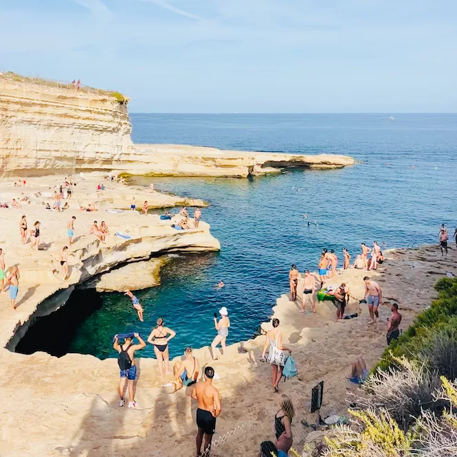
The water in St. Peter’s Pool is crystal clear blue. It’s perfect for snorkeling. Fish swim alongside people, enhancing the experience. The area isn’t huge, so it gets crowded in summer. But in winter, it’s serene and quiet.
Join my FREE private Facebook group, Malta Travel Tips, where you’ll find helpful resources and connect with other travellers just like you!
Heading back to St. Thomas Bay
As you’re ready to head back to St. Thomas Bay, there are two options. The first option is to retrace your steps and walk back along the same coastal path you took earlier. Or, you can follow the map provided and take the road back.
The road is quiet, but some cars pass by, so be careful while walking. The road route is more effortless and quicker, taking only half the time of the coastal path.
The St. Thomas Bay to St. Peter’s Pool hike is a must-do for anyone looking for an adventure in Malta’s south. The scenic views of the white cliffs, crystal-clear waters, and lush greenery make this hike unforgettable.
While the hike may be challenging in some areas, the reward is well worth it. You’ll see the most beautiful sights in the South of Malta. And if you’re up for a swim or a snorkel, there are plenty of opportunities to take a dip in the clear waters along the way.
But this hike is the tip of the iceberg. Malta offers a variety of other beautiful hikes that are waiting for you.
Wander through the untouched beauty of Il-Blata tal-Melh, Wied Babu and Fawwara, stroll along the coast from Ghajn Tuffieha to Gnejna Bay, or take a trek along the Victoria Lines. Experience the grandeur of the cliffs from Ras id-Dawwara to Miġra l-Ferħa or Dingli. Also, check out my blog post on the hidden gems of Malta.