Just a quick heads up – some of the links I share on this site are affiliate links. That means if you click on one and make a purchase, I may earn a small commission at no extra cost to you. Your support through these links helps me create valuable content.
If you’re looking for an unforgettable hiking adventure along Malta’s cliffs, you’ve come to the right place. A hike from Ras id-Dawwara Valley to Miġra l-Ferħa will take you through terraced hills and rugged coastline. You will see sea caves, a lush valley with almond trees, and a tiny gorge that leads right down to the sparkling sea.
I’ve been living in Malta since 2011 and have explored every corner of this beautiful island. Trust me, the cliffs on the west side are an absolute must-see.
I know planning a hike in a new place can feel overwhelming, but don’t worry – I’ve got you covered. In this post, you will get all the info you need to navigate the trails and see all the incredible sights.
I have included a hiking map, listed all the sights along the way, and shared some helpful hiking tips. So grab your hiking boots and let’s go!
- Distance: 7 km
- Walking Time: 2 h
- Level: Intermediate
- Uphill: 250 m
- Downhill: 250 m
- Highest Point: 200 m
The best time to go: any time, but avoid the midday heat from June to September.
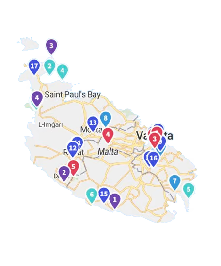
Malta’s Cliffs Hike Map
How Did I Discover this Hike?
It was totally by chance that I found this fantastic hike along Malta’s cliffs. It was several years ago when I followed an online trekking guide. I was not too fond of the route because we had to walk along the road. Many cars and trucks passed by, and it was noisy and polluted.
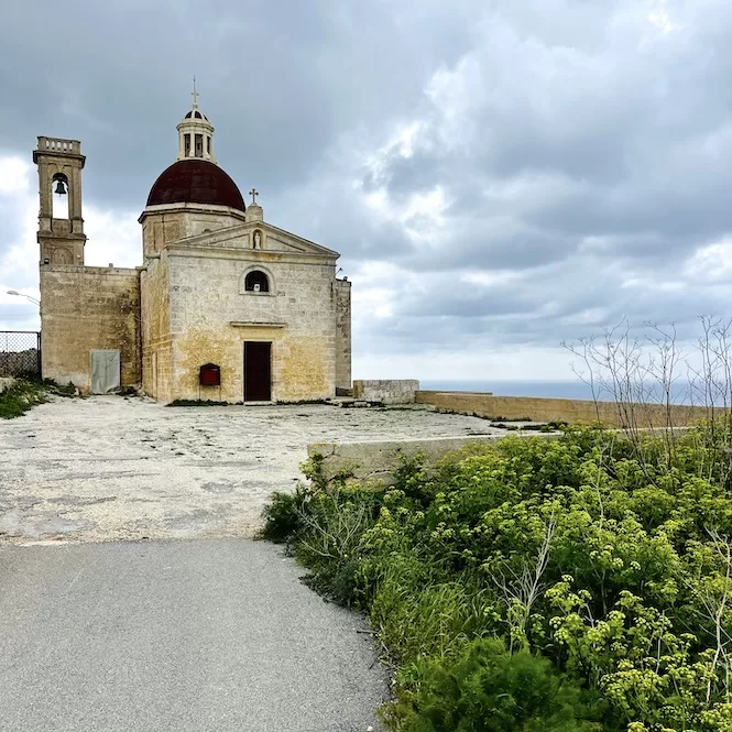
Then I spotted a path going towards the sea. Tempted, I followed it and soon found a gorgeous, serene chapel called Mtahleb Church. I was amazed by the views and how peaceful it was.
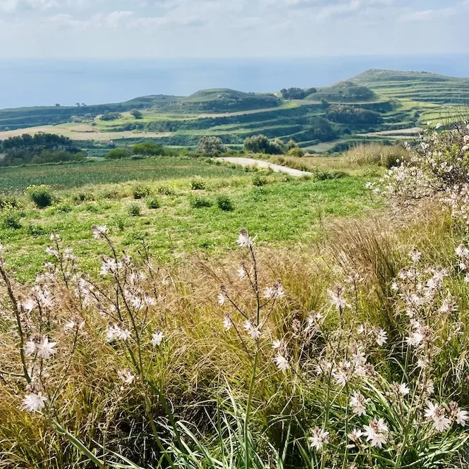
When I walked away from the medieval chapel, I decided to walk towards the sea. In no time, I came to a viewpoint with fantastic views of green hills.
I was excited to have discovered such a hidden gem in Malta. It’s funny because even my Maltese friends haven’t been here. There’s something special about this hike, and I can’t wait to share it with you.
What Should You Know Before Hiking?
This hike along Malta’s cliffs is 7 km long return. There’s a steep downhill at the beginning and an uphill at the end. You’ll walk on paved and natural paths. It’s wise to wear comfortable shoes. Bring your food and drinks because there won’t be anything to buy.
If the wind is strong, take something to cover your ears. Also, if it’s windy, stay away from the cliff edge, so you don’t fall. It’s also helpful to download Google Maps and Komoot maps for offline use because there’s no internet connection in some parts of the hike.
Getting to the Starting Point of the Hike
To get to this hike, you have to drive through the town of Rabat. If you’re taking public transportation, the closest bus stop is 2.3 km away. Or else, you can take a bus to Rabat and a taxi from there. Rabat is served by many buses frequently.
Getting there by car is faster and easier. Below is the exact location.
The public transportation in Malta is quite okay but it can be very slow if you want to see more remote places. It is best to rent a car, especially if you plan on staying longer than just a few days. Check out my guide to car rentals in Malta.
Getting There:
- Location: link to Google Maps
- Nearest bus stop: Bajdar (2.30 km away). There is a bus 109 that goes from Birkirkara and through Rabat.
- Frequency of the buses: every hour
- Parking available: Along the road, there is plenty of parking
Get a FREE Attractions Map
Planning a trip to Malta, Gozo, or Comino? Get this free interactive map filled with insider tips, Google Maps links, and more.
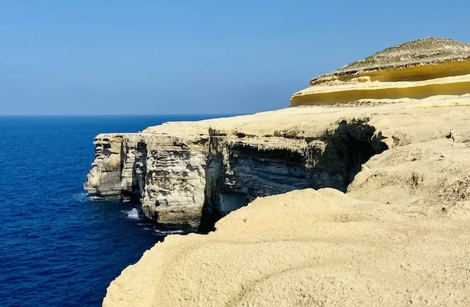
Ras id-Dawwara Valley and Cliffs
I usually park along the road here which I marked on the map as a starting point of this hike.
You can visit the Mtahleb Church. It’s optional, so I didn’t include it on the hiking map. Or else, go straight to the viewpoint mentioned before.
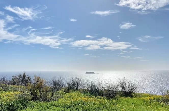
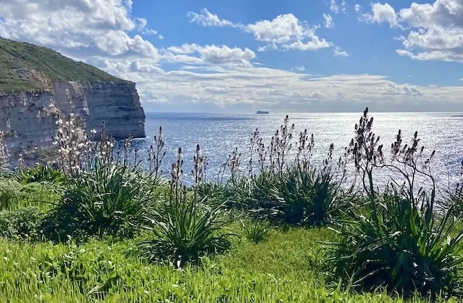
Here is the viewpoint location. In winter and spring, the view is especially beautiful. The hills are bright green and look like rice fields in Asia. And in spring, you’ll see almond trees blooming along the way.
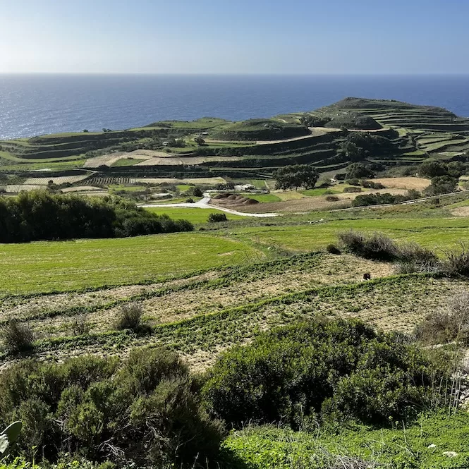
Take in the scenery as you walk down the road. A farm will be on your left, where people might work in the fields. At some point, the road will end, and you’ll have to follow a small path. Continue down the path until you get to Ras id-Dawwara Valley.
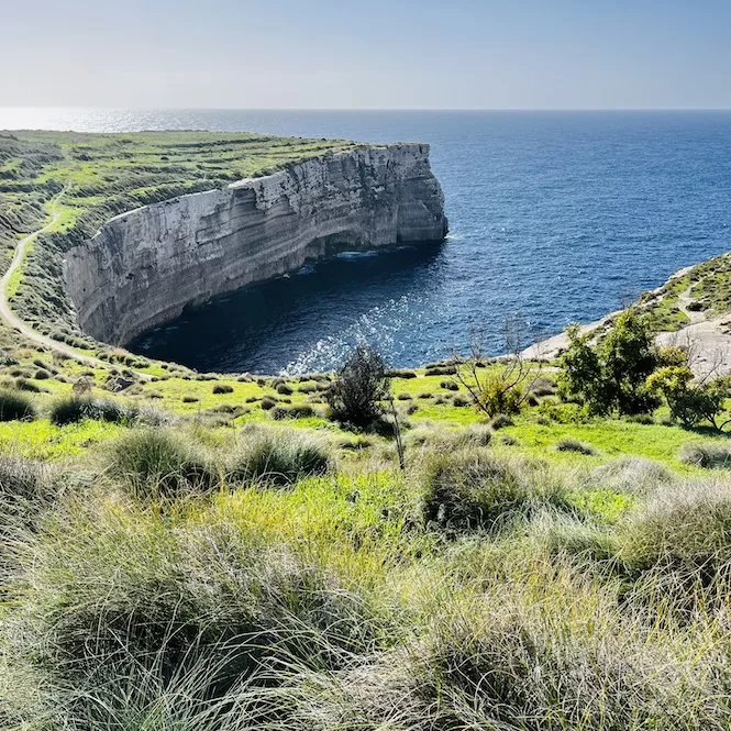
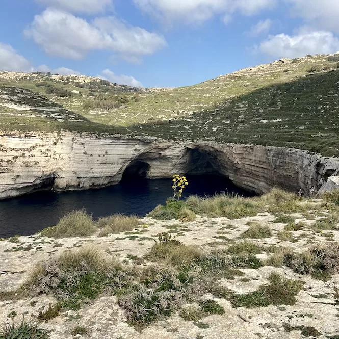
Ras id-Dawwara is a hiking place in Malta. You’ll walk along stunning cliffs with a breathtaking view of Filfa. Look out for the caves at water level – a striking sight from above. The sound of wind and waves will surround you with each step.
Ras id-Dawwara Valley is a place for Malta’s only waterfall, visible post-rain. Water flows down the valley, forming a stunning waterfall. If you are in the area after a heavy rain, make sure you visit Ras id-Dawwara to enjoy this natural wonder.
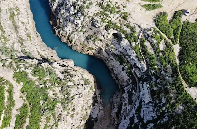
Explore Miġra l-Ferħa
Using the Kamoot map on this blog, you can see that the route turns right. Explore the cliffs from all sides if you’re not in a hurry.
Miġra l-Ferħa is next on the hike. There’s a 40-minute walk from Ras id-Dawwara Valley. There’s a clear path that leads to this area. You’ll get to enjoy Malta’s cliffs on the way.
This part of the hike is a bit more popular, but it’s not crowded. The large parking area at Miġra l-Ferħa makes it easily accessible. So, it is a popular place for picnics and sunset watching.
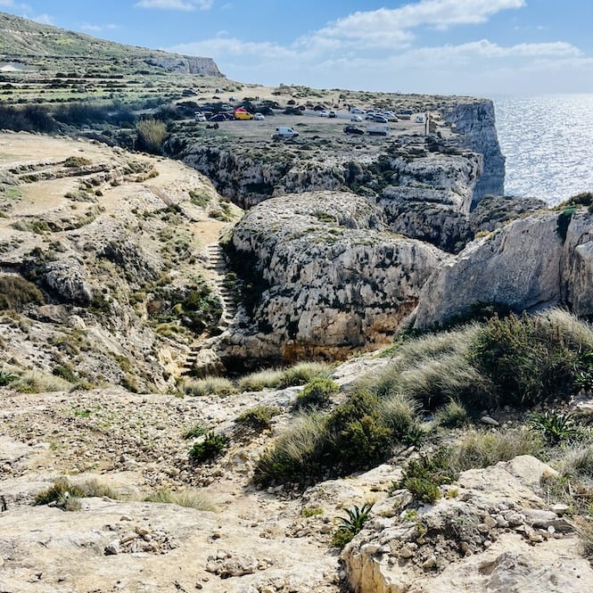
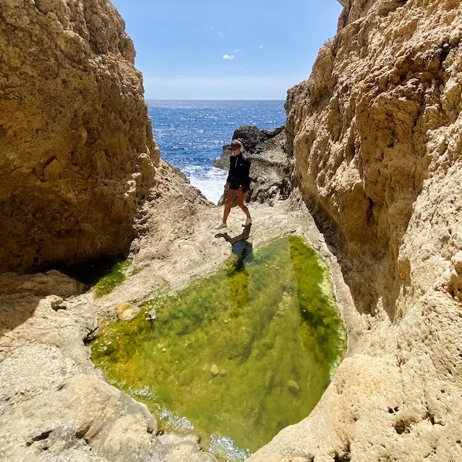
There’s also a tiny gorge you can visit. There are old stairs to get down to the sea. The deep blue water below is stunning. You will also hear waves crashing against the rocks.
In conclusion, this 7 km hike in Malta is a hidden gem that offers breathtaking views of cliffs, valleys, and the sea. It is the perfect way to taste Malta’s natural beauty.
If you’re looking for more hiking guides in Malta and Gozo, look no further!
- Busket to Dingli Cliffs
- Selmun Palace Hike
- Paradise Bay Hike
- Fawwara Hike
- Mgarr Harbour to Xlendi in Gozo
- Salt Pans Hike to Ghasri Valley
- Victoria Lines Hike
- Hike to St Peter’s Pool
- Hike from Ghajn Tuffieha to Gnejna Bay
- Wied Babu Hike
Have questions about your Malta trip? Join my FREE private Facebook group, Malta Travel Tips, where you can find helpful resources and connect with fellow travellers!