Just a quick heads up – some of the links I share on this site are affiliate links. That means if you click on one and make a purchase, I may earn a small commission at no extra cost to you. Your support through these links helps me create valuable content.
If you’re looking for a guide to Dingli Cliffs in Malta, you’ve come to the right place. I’ve lived in Malta since 2011 and I’ve been to these cliffs more times than I can count, for sunsets, hikes, and to show visitors a completely different side of the island. This is the guide I wish I’d had.
You’ll find the best viewpoints, honest seasonal advice, where to eat, and practical tips from someone who actually lives here. Ready? Let’s dive in.

Written by Laura Jasenaite, Malta travel expert with 15+ years living on the islands.
What Are Dingli Cliffs?
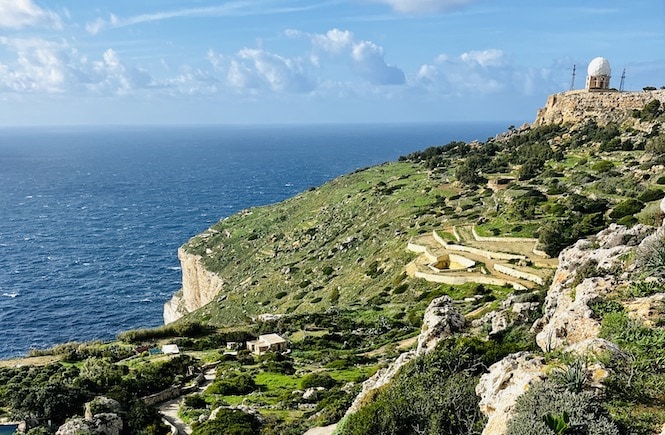
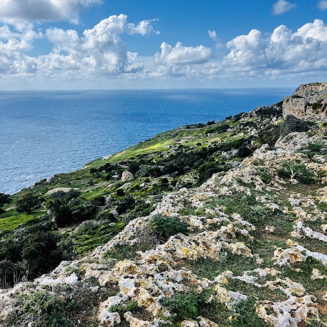
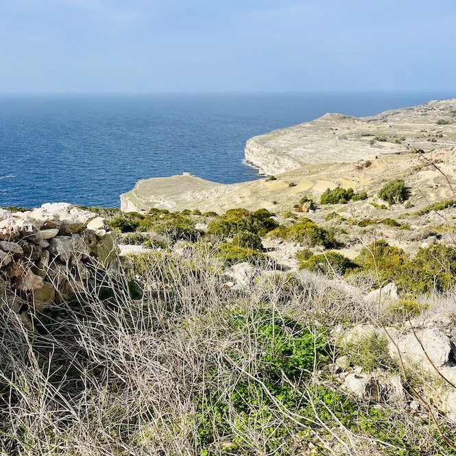
Dingli Cliffs are Malta’s highest point, rising to around 250 metres above the Mediterranean Sea on the island’s southwest coast. The rock is Upper Coralline Limestone, shaped over millions of years by wind and waves.
What strikes most people when they first stand at the edge is the sense of scale. The cliffs are tall enough that the waves crashing below never reach you; you just hear them. That sound, combined with the open sea and the small uninhabited islet of Filfla on the horizon, makes this one of the most atmospheric spots in Malta.
Unlike most tourist attractions on the island, Dingli Cliffs has no entrance fee, no queue, and no rush. It is one of the few places in Malta where you genuinely feel like you’re escaping.
How to Get to Dingli Cliffs
Dingli Cliffs are on Malta’s southwest coast, about 16 kilometres from Valletta. Getting there is straightforward whether you drive or take the bus.
By car: Driving is the easiest option. Parking is available along the road near St Mary Magdalene Chapel, next to the main viewpoint and walking track. If you need a rental, here is a guide to Malta car rental.
By bus: Bus 201 connects the airport with Rabat, Dingli, Siggiewi, and Zurrieq. The nearest stop to the cliffs is Maddalena at Had-Dingli. If you’re coming from St Julian’s or Sliema, the journey takes a while, so I’d recommend avoiding peak weekday times and going mid-morning or mid-afternoon instead. For more transport options, see my guide on how to get around Malta.
You can also get off in Dingli town centre and walk about 15 minutes to the cliffs.
Getting there:
- Location: Google Maps
- Nearest bus stop: Maddalena. Bus 201 connects the airport with Zurrieq, Rabat, and Dingli.
- Frequency of buses: every hour
- Parking: plenty of parking along the road near the chapel
The Best Time to Visit Dingli Cliffs
Any time of year is a good time to visit Dingli Cliffs, though spring is when the landscape is at its most spectacular. Here is what each season is actually like.
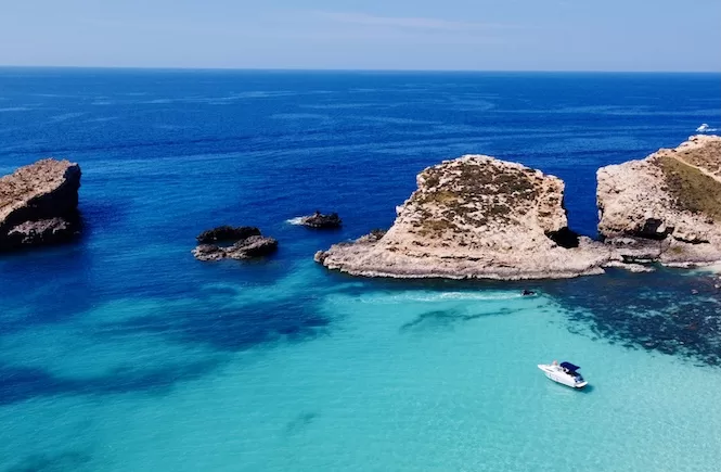
From June to September, Malta bakes in the heat, but Dingli Cliffs stays breezy because of the altitude. Evening visits are particularly good in summer: the temperature drops, the light turns golden, and the sunsets can be extraordinary. If you want to know the best places to see sunsets in Malta, the cliffs are near the top of any honest list.
Autumn brings cooler temperatures and the landscape starts to recover its colour. It is a pleasant time to visit with fewer crowds than summer.
Winter at Dingli Cliffs is surprisingly beautiful. The cliffs are green, the air is clear, and on windy days you can hear the waves crashing far below. Because the cliffs are over 250 metres high, the waves never reach you, but the sound of them is something else. Bring a windbreaker, because it can be cold and gusty up there even when the rest of Malta feels mild.
Spring is my personal favourite. The hillsides are covered in wildflowers and the whole area turns lush green. It is the kind of scenery that makes you stop and take photographs of things that are not even tourist attractions: just fields and rocky paths and colour everywhere. For more on planning your trip around the seasons, see my guide to the best time to visit Malta.
Get a FREE Attractions Map
Planning a trip to Malta, Gozo, or Comino? Get this free interactive map filled with insider tips, Google Maps links, and more.
Dingli Cliffs: The Best Viewpoints
Dingli Cliffs has several distinct viewpoints, each offering a different perspective of the Mediterranean coastline. Here are the ones I recommend, with a map of the area to help you plan.
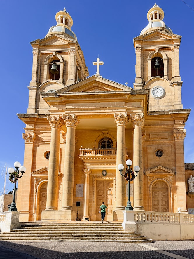
St Mary Magdalene Chapel Area
The St Mary Magdalene Chapel area is the most popular starting point at Dingli Cliffs. There is a large car park, a few benches along the cliff edge, and on weekends a small truck sells coffee, tea, and sweets nearby.
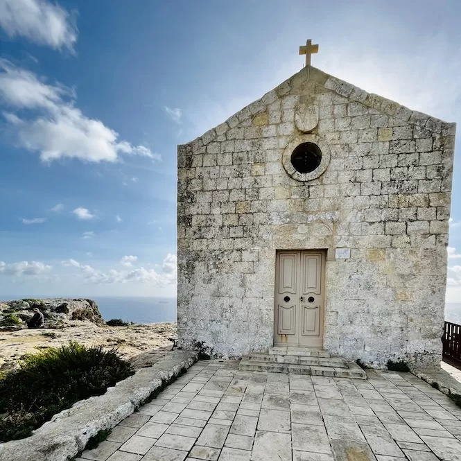
The chapel itself is dedicated to Mary Magdalene and is a remarkable historical site. Records mention it as early as 1446, though the exact date of construction is unknown. It is also known as the Chapel of the Cliffs, named for its position above the sea.
Bronze Age Village Il-Wardija ta’ San Ġorġ
The Wardija ta’ San Ġorġ settlement is another viewpoint along the cliffs, rich in both views and history. To get there, follow Triq Panoramika south. The settlement dates back to between 2400BC and 800BC and is notable for its rock-cut silo pits, likely used to store water and grain. Reaching it involves a 200-metre walk on an uneven path, so wear sturdy shoes.
Triq Panoramika Cliffside Walk
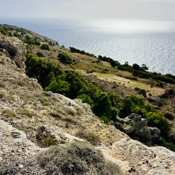
The easiest way to take in the views is simply to walk along Triq Panoramika, the road that runs along the cliff edge. This path stretches for over three kilometres, with a proper pedestrian pavement heading north from the chapel. There are benches at intervals where you can stop and sit with the sea in front of you. It is well maintained and suitable for most walkers, though keep a sensible distance from the cliff edge.
The Panoramic View of Ras id-Dawwara
My favourite viewpoint is at the end of Triq Panoramika, overlooking Ras id-Dawwara. The panorama here is more expansive than anywhere else along the cliffs: you see the bay, the rocky coastline, and small village roads stretching into the farmland behind. Because it is at the far end of the road and not widely known, it is usually quiet even when the chapel area is busy.
It is about a three-kilometre walk from the chapel, or you can drive and park along the side road. Either way, it is worth the effort.
What to Do at Dingli Cliffs
Most people come to Dingli Cliffs to escape, and once you are there, you will understand why. It is not a busy place. The road is quiet, there are no souvenir shops, and the main attraction is simply the view and the open air.
Many locals come just to walk. There is a paved road with benches along the cliff edge, and it is perfectly pleasant to stroll up and down with nothing in particular planned. Others come specifically for the sunset. If you want to know what that looks like, find a good spot on the rocks facing west and bring something to sit on. The light at Dingli in the evening is one of Malta’s better-kept secrets.
If you are more active, the cliffs are a great base for hiking. Trails head north towards Fawwara and south towards the Ras id-Dawwara area; I have covered these in the hiking section below. Some people also come by bicycle, and it is not unusual to see quad bikes on the road. For sunset ideas across the island, see my guide to the best sunsets in Malta.
Where to Eat at Dingli Cliffs
There are two restaurants at Dingli Cliffs and a small food truck near the chapel. Here is what to expect from each.
Bobbyland Restaurant is right on the cliff road, with an outdoor seating area overlooking the sea. It serves Maltese and Mediterranean dishes and is open for lunch. If you want to try something local, the traditional snail dish is worth ordering. I have been there for drinks rather than food and found it a perfectly pleasant spot to sit with a view.
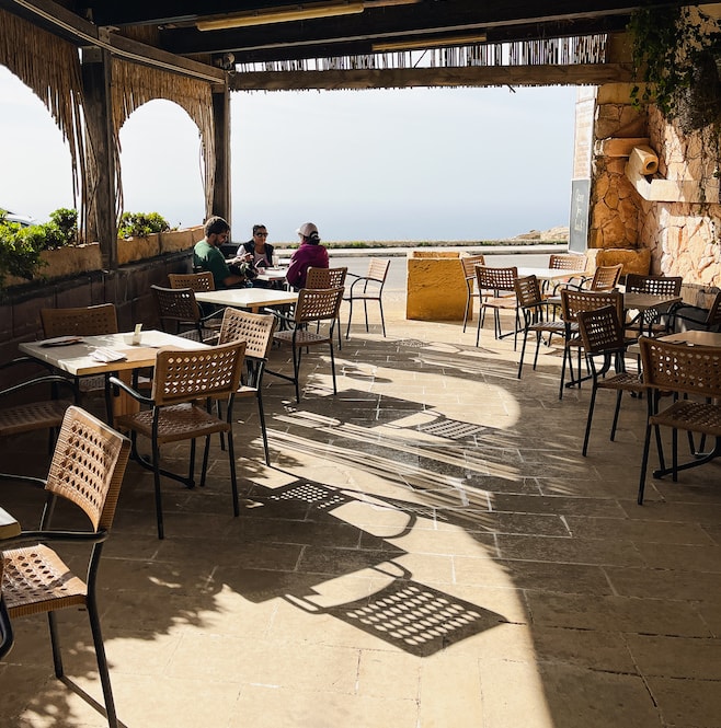
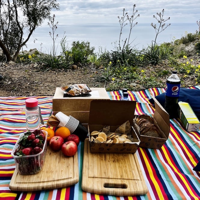
The Cliffs is the other restaurant in the area. It grows many of its own herbs and vegetables, which makes the food feel fresh and properly seasonal. It is open for lunch; check Google Maps for hours in summer as these can vary. I once got a vegetarian platter to take away and ate it as a picnic on the cliffs, which was a great idea. I would recommend doing the same.
Next to St Mary Magdalene Chapel there is a small truck selling coffee, tea, and sweets, particularly on weekends. It is more of a convenient stop than a food destination, but good for a warm drink if you are there in winter.
If you plan to eat at either restaurant, I recommend checking their hours and booking ahead, especially on weekends.
Want to plan your whole Malta trip without the stress?
My 7-Day Malta Itinerary handles the routes, timings, and where to start, so you can just be there. Less planning. More Malta.
Hiking Trails Near Dingli Cliffs
The Dingli Cliffs area has three well-marked hiking trails, ranging from easy to moderate difficulty. Here are the three I recommend.
Fawwara Trail:
This is a 6.7 km trail offering sea views, green fields, and a sightline to Filfla islet. It starts and ends at St Mary Magdalene Chapel and takes around 1 hour 50 minutes. Suitable for moderate fitness. Here is a complete guide to the Fawwara hike.
Buskett Gardens to Dingli Cliffs:
Starting and ending at Buskett Gardens, this hike is 5 km and takes about 1 hour 20 minutes. It is suitable for any fitness level and offers natural landscapes and panoramic cliff views. For more, check this guide to the Buskett to Dingli hike.
Dingli Town to Dingli Cliffs:
This circular route starts and ends in Dingli village, covering about 6 km in approximately 1 hour 35 minutes. It is ideal for moderate fitness and takes you through Dingli town, with sea views and rural landscapes along the way.
Each of these hikes showcases the natural beauty of the area. Wear comfortable shoes, bring water, and check the weather before you go, as it can be breezy up on the cliffs even on a warm day. For more options, see my guide to the best hiking trails in Malta and Gozo.
Practical Tips for Visiting Dingli Cliffs
A few practical things to know before you visit will help you make the most of your time at the cliffs.
For a sunset visit: Bring snacks, something to sit on, and a drink. There is no cafe open late, so come prepared if you are planning to stay for the evening light. The rocks along the cliff edge make a perfectly good seat.
For hiking: Wear good shoes. The paths around Dingli Cliffs involve rocky, uneven surfaces, so trainers or hiking shoes are much more comfortable than sandals.
In winter: Bring a windbreaker. Even on a mild winter day in Malta, the cliffs can be cool and windy. The temperature at the top feels noticeably lower than in the villages below.
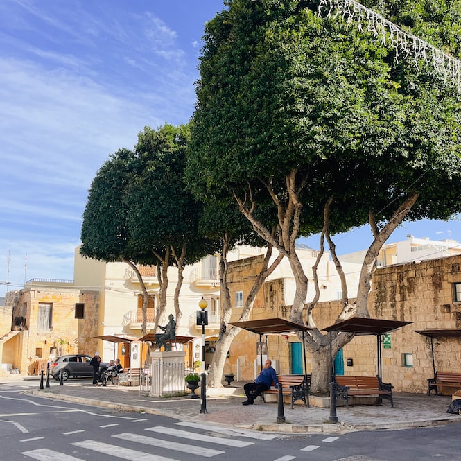
Exploring Dingli Town
Dingli Town is a quiet, untouristy Maltese village just a few minutes from the cliffs. After the views and the open air of the clifftop, it is a nice contrast: narrow streets, stone houses, and a pace of life that has nothing to do with tourism.
You can wander the town’s pretty streets, visit St Mary’s Parish Church, and try local Maltese food. It is the kind of village where not much is happening, and that is exactly the point.
Dingli Cliffs: Frequently Asked Questions
Are Dingli Cliffs worth it?
Yes, Dingli Cliffs are worth visiting. They offer some of the most dramatic views in Malta: open sea, a sense of real scale, and none of the crowds you find at places like Valletta or the Blue Lagoon. If you only have a few days in Malta, I would not make them a full-day trip, but a sunset visit is genuinely one of the best things you can do on the island.
How high are Dingli Cliffs Malta?
Dingli Cliffs are around 250 metres high, making them the highest point in Malta. The waves crash far below but never reach the top; on a windy day, you hear them rather than see them, which gives the place a very particular atmosphere.
What is the highest point in Malta?
The highest point in Malta is Dingli Cliffs, at around 250 metres above sea level. They stand on the island’s southwest coast and are visible from the sea on a clear day.
What is the history of Dingli?
Dingli’s history goes back to ancient times, with tombs from Phoenician, Carthaginian, and Roman eras found in the area. There was once a village called Hal Tartarni here, with a significant church that is now in ruins. Over time, people moved to where modern Dingli stands. During the rule of the Order of Saint John, the Dingli area was considered safe from coastal pirate raids precisely because of the height and inaccessibility of its cliffs.
How long are Dingli Cliffs?
Dingli Cliffs stretch for around five kilometres along Malta’s southwest coast. The main viewpoint and road along the top, Triq Panoramika, covers over three kilometres and is walkable in both directions from the chapel.
What does “Dingli” mean?
The name “Dingli” is thought to derive from Sir Thomas Dingley, an English knight in the Order of St John who owned much of the land in the area. His name, over time, became the name of the town.
Malta’s Dingli Cliffs offer dramatic views, a genuine sense of quiet, and some of the best hiking on the island. Whether you come for a sunset picnic, a morning walk, or a full day of trails, it is one of those places that rewards you every time. Nearby, Rabat, Mdina, and Buskett Gardens are all worth combining into the same trip. For more ideas, see my full guide to hiking trails in Malta and Gozo.